
11.5: Water on and in the Geosphere
- Page ID
- 285359

\( \newcommand{\vecs}[1]{\overset { \scriptstyle \rightharpoonup} {\mathbf{#1}} } \)
\( \newcommand{\vecd}[1]{\overset{-\!-\!\rightharpoonup}{\vphantom{a}\smash {#1}}} \)
\( \newcommand{\id}{\mathrm{id}}\) \( \newcommand{\Span}{\mathrm{span}}\)
( \newcommand{\kernel}{\mathrm{null}\,}\) \( \newcommand{\range}{\mathrm{range}\,}\)
\( \newcommand{\RealPart}{\mathrm{Re}}\) \( \newcommand{\ImaginaryPart}{\mathrm{Im}}\)
\( \newcommand{\Argument}{\mathrm{Arg}}\) \( \newcommand{\norm}[1]{\| #1 \|}\)
\( \newcommand{\inner}[2]{\langle #1, #2 \rangle}\)
\( \newcommand{\Span}{\mathrm{span}}\)
\( \newcommand{\id}{\mathrm{id}}\)
\( \newcommand{\Span}{\mathrm{span}}\)
\( \newcommand{\kernel}{\mathrm{null}\,}\)
\( \newcommand{\range}{\mathrm{range}\,}\)
\( \newcommand{\RealPart}{\mathrm{Re}}\)
\( \newcommand{\ImaginaryPart}{\mathrm{Im}}\)
\( \newcommand{\Argument}{\mathrm{Arg}}\)
\( \newcommand{\norm}[1]{\| #1 \|}\)
\( \newcommand{\inner}[2]{\langle #1, #2 \rangle}\)
\( \newcommand{\Span}{\mathrm{span}}\) \( \newcommand{\AA}{\unicode[.8,0]{x212B}}\)
\( \newcommand{\vectorA}[1]{\vec{#1}} % arrow\)
\( \newcommand{\vectorAt}[1]{\vec{\text{#1}}} % arrow\)
\( \newcommand{\vectorB}[1]{\overset { \scriptstyle \rightharpoonup} {\mathbf{#1}} } \)
\( \newcommand{\vectorC}[1]{\textbf{#1}} \)
\( \newcommand{\vectorD}[1]{\overrightarrow{#1}} \)
\( \newcommand{\vectorDt}[1]{\overrightarrow{\text{#1}}} \)
\( \newcommand{\vectE}[1]{\overset{-\!-\!\rightharpoonup}{\vphantom{a}\smash{\mathbf {#1}}}} \)
\( \newcommand{\vecs}[1]{\overset { \scriptstyle \rightharpoonup} {\mathbf{#1}} } \)
\( \newcommand{\vecd}[1]{\overset{-\!-\!\rightharpoonup}{\vphantom{a}\smash {#1}}} \)
\(\newcommand{\avec}{\mathbf a}\) \(\newcommand{\bvec}{\mathbf b}\) \(\newcommand{\cvec}{\mathbf c}\) \(\newcommand{\dvec}{\mathbf d}\) \(\newcommand{\dtil}{\widetilde{\mathbf d}}\) \(\newcommand{\evec}{\mathbf e}\) \(\newcommand{\fvec}{\mathbf f}\) \(\newcommand{\nvec}{\mathbf n}\) \(\newcommand{\pvec}{\mathbf p}\) \(\newcommand{\qvec}{\mathbf q}\) \(\newcommand{\svec}{\mathbf s}\) \(\newcommand{\tvec}{\mathbf t}\) \(\newcommand{\uvec}{\mathbf u}\) \(\newcommand{\vvec}{\mathbf v}\) \(\newcommand{\wvec}{\mathbf w}\) \(\newcommand{\xvec}{\mathbf x}\) \(\newcommand{\yvec}{\mathbf y}\) \(\newcommand{\zvec}{\mathbf z}\) \(\newcommand{\rvec}{\mathbf r}\) \(\newcommand{\mvec}{\mathbf m}\) \(\newcommand{\zerovec}{\mathbf 0}\) \(\newcommand{\onevec}{\mathbf 1}\) \(\newcommand{\real}{\mathbb R}\) \(\newcommand{\twovec}[2]{\left[\begin{array}{r}#1 \\ #2 \end{array}\right]}\) \(\newcommand{\ctwovec}[2]{\left[\begin{array}{c}#1 \\ #2 \end{array}\right]}\) \(\newcommand{\threevec}[3]{\left[\begin{array}{r}#1 \\ #2 \\ #3 \end{array}\right]}\) \(\newcommand{\cthreevec}[3]{\left[\begin{array}{c}#1 \\ #2 \\ #3 \end{array}\right]}\) \(\newcommand{\fourvec}[4]{\left[\begin{array}{r}#1 \\ #2 \\ #3 \\ #4 \end{array}\right]}\) \(\newcommand{\cfourvec}[4]{\left[\begin{array}{c}#1 \\ #2 \\ #3 \\ #4 \end{array}\right]}\) \(\newcommand{\fivevec}[5]{\left[\begin{array}{r}#1 \\ #2 \\ #3 \\ #4 \\ #5 \\ \end{array}\right]}\) \(\newcommand{\cfivevec}[5]{\left[\begin{array}{c}#1 \\ #2 \\ #3 \\ #4 \\ #5 \\ \end{array}\right]}\) \(\newcommand{\mattwo}[4]{\left[\begin{array}{rr}#1 \amp #2 \\ #3 \amp #4 \\ \end{array}\right]}\) \(\newcommand{\laspan}[1]{\text{Span}\{#1\}}\) \(\newcommand{\bcal}{\cal B}\) \(\newcommand{\ccal}{\cal C}\) \(\newcommand{\scal}{\cal S}\) \(\newcommand{\wcal}{\cal W}\) \(\newcommand{\ecal}{\cal E}\) \(\newcommand{\coords}[2]{\left\{#1\right\}_{#2}}\) \(\newcommand{\gray}[1]{\color{gray}{#1}}\) \(\newcommand{\lgray}[1]{\color{lightgray}{#1}}\) \(\newcommand{\rank}{\operatorname{rank}}\) \(\newcommand{\row}{\text{Row}}\) \(\newcommand{\col}{\text{Col}}\) \(\renewcommand{\row}{\text{Row}}\) \(\newcommand{\nul}{\text{Nul}}\) \(\newcommand{\var}{\text{Var}}\) \(\newcommand{\corr}{\text{corr}}\) \(\newcommand{\len}[1]{\left|#1\right|}\) \(\newcommand{\bbar}{\overline{\bvec}}\) \(\newcommand{\bhat}{\widehat{\bvec}}\) \(\newcommand{\bperp}{\bvec^\perp}\) \(\newcommand{\xhat}{\widehat{\xvec}}\) \(\newcommand{\vhat}{\widehat{\vvec}}\) \(\newcommand{\uhat}{\widehat{\uvec}}\) \(\newcommand{\what}{\widehat{\wvec}}\) \(\newcommand{\Sighat}{\widehat{\Sigma}}\) \(\newcommand{\lt}{<}\) \(\newcommand{\gt}{>}\) \(\newcommand{\amp}{&}\) \(\definecolor{fillinmathshade}{gray}{0.9}\)The geosphere is the repository of virtually all the world’s fresh water. As shown in Figure11.2, this water may be in underground aquifers as groundwater; on the surface as streams, rivers, lakes and impoundments; or as deposits of ice (glaciers) resting on Earth’s surface. Water collected
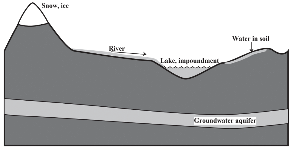
Figure 11.3. Major aspects of water on and in the geosphere
by the geosphere constitutes virtually all Earth’s fresh water resources. This water is susceptible to pollution which in extreme cases can render the water sources virtually useless. One of the greater water pollution problems is when water in underground aquifers becomes contaminated with hazardous waste material improperly discarded in the geosphere.
Water commonly moves on the geosphere in streams or rivers consisting of channels through which water flows. Rivers collect water from drainage basins or watersheds. In order to protect water quality in rivers, pollution and pollution-causing agricultural practices in drainage basins must be avoided. Rivers continually erode the geosphere over which they flow and leave deposits of sediments. Over time, a river will erode earth away and create valleys. An undisturbed river continually cuts curving patterns known as meanders in a river valley. The flat area of a valley formed by erosion and sediment deposition in the valley and susceptible to periodic flooding is the river's floodplain.
Floods are the phenomena associated with river flow that are most likely to cause damage to human structures. Despite their destructiveness, floods are normal phenomena by which a river does much of its work of shaping the surface of the geosphere. However, by unwisely building in flood plains, humans have made themselves susceptible to the damaging effects of floods. This was illustrated most tragically by the deadly flood of the city of New Orleans following the 2005 Hurricane Katrina in which many of the areas flooded were built below sea level! Human activities on the geosphere surface can make the effects of floods much worse. For example, flash floods following intense rainfall in urban areas are made much worse by the removal of vegetation from watersheds and its replacement with paving. Concrete and asphalt surfaces do not slow down the flow of water like well-rooted plants do and such surfaces prevent the infiltration of water into the ground.
Attempts to control water flow and flooding provide interesting examples of how humans can interact with their natural environment. Control measures have concentrated on the downstream end on the rivers themselves by construction of levees to confine rivers to their banks, straightening and deepening river channels to increase the velocity and flow of the water in an effort to move it quickly downstream away from the potentially flooded area, and by building dams to contain floodwater until it can be safely released. Such measures can be deceptively successful, sometimes for many decades, until a massive flood overwhelms them. When a contained river carrying vast amounts of water flowing at a high velocity eventually breaks through the levees and dams designed to contain it, the resulting damage can be catastrophic.
An approach to flood control based upon the best practice of sustainability provides a means of minimizing flood damage. Such an approach tends to concentrate more on the upstream end, the watersheds from which water produced by rainfall flows into the river. With the proper kind of vegetation cover, such as forests, and with terraces and small dams designed to temporarily slow the flow of water into the river from the watershed, extremes of high water (flood crests) can be greatly reduced. With regard to protection of dwellings and agricultural land in the river’s floodplain, a fundamental question has to be asked whether houses should even be located in these areas and whether the land should be cultivated. In many cases, the answer is no, and the least costly alternative overall is to pay for removal of the structures and conversion of the land back to an uncultivated state, simply allowing the flooding that comes naturally to the river.